Showing posts with label Geology. Show all posts

Thursday, December 13, 2012

What Color Is Soil ?


streaks of colored soil
no roads, no tracks, no people
eager to explore


(Click on photo to enlarge)


Photo Location:  Dinosaur National Monument,  (Dinosaur)  Colorado (Colorado)

Tuesday, November 6, 2012

Wrinkled Earth


foot in the pines,  juniper capped
a checkerboarded monolith
horizontal bedding structures
expansion versus contraction
cause shallow vertical fractures
in orange-gray Navajo sandstone
classic sedimentary rock
extravagant geology
a trophy of old wrinkled earth


(Click on photo to enlarge)
 
 
Photo Location:  Zion National Park,  (Zion)  Utah
 

Friday, September 28, 2012

"Horizontality"


"Horizontality"
 

Early autumn pushing
band of yellow.

Late summer lingering
strip of green.

Ancient drift deposits
platter of boulders.

Wall of spruce climbs
background slope.

Bulge of rock ringed
with dark pines.

Ribbon of river weaves
through meadow's floor.

Terrestrial table spread
with horizontality.


(Click on photos to enlarge)


Yellow  =  Narrow-leaf Cottonwood  (Populus  angustifolia)

Green  =  Trembling Aspen  (Populus  tremuloides)


Photo Location:  Rocky Mountain National Park, (RMNP) Colorado (Colorado)


Thursday, September 13, 2012

Inner Earth


steam water gurgles
over terraced minerals
inner earth exhales


Photo Location:  Mammoth Hot Springs - Yellowstone National Park,  Wyoming (Wyoming)
 
 
(Click on Photo to enlarge)

Friday, July 13, 2012

A Hike We Like: Cedar Breaks


Look at a road map of Utah, and let your eyes drift to the southern 1/3 of the state. Examine the massive expanse of land east of I-15, and south of I-70. Here you will find five National Parks, four National Monuments, and the huge Glen Canyon Recreation Area. Not to mention several National Forests, Primitive Areas, and Wilderness areas. About 20,000 square miles! Nearly the size of West Virginia.
How To Get There:

Come east off I-15 (Exit 59) through Cedar City, Utah (home of the Shakespeare Festival) Take route 14 ESE 18 miles to route 148.Turn North (left) on 148. From miles 2-6 you have several places to stop and walk sections of the trails:

Spectre Point, Ramparts Overlook Trail, Point Supreme, Sunset View, the Visitor Center, The Campground, Chessmen Ridge Overlook, Cedar Breaks Amphitheater, North View, and Alpine Pond Loop Trail.

FDR (Franklin Delano Roosevelt) declared this 9.6 square mile area a National Monument in 1933.

This is an easy hike with many photo opportunities. Mary and I walked several sections of trail along the rim of this canyon. The elevation here is about 10,000 to 10,350 feet, with little elevation change on the trails.

On one side it's dense with Firs, Pines, Spruce, Cedars, wildflowers and shade.  On the other side you're looking into a colorful amphitheater, 2,500 feet deep! The reddish-pinkish-orange color comes from various amounts of iron oxides. The sedimentary rock that you see is limestone.The different formations, hoodoos, fins, arches, and shallow caves are formed by erosion.

The trails are more of a walk than a hike, so as we go, I will show you the vistas and voodoos on one side, and the wildflowers at the edge of the evergreens on the other side. If you see me too close to the edge of the canyon, please grab me. Sometimes I get carried away when I'm taking photographs. Be sure you have lots of water along. Here we go...


Beardstongue (Blue Penstemon) (Penstemon cyaneus)


Columbine (Aquilegia coerulea)


Mountain Blue Bell (Mertensia ciliata)


Lupine (Lupinus sp.)


Indian Paintbrush (Castillega mineata)


(Click on any photo to enlarge)


Did you enjoy the views? You know, and I know, that being there, exploring it yourself, and feeling the exhilaration is 1,000 times better than this little bloggy glimpse. But I do know you will be impressed when you take this walk along the rim.

I hope you get an opportunity to experience this "hike we like" in Cedar Breaks National Monument.
It's monumental! And it's in...

Utah !    (Utah)

Wednesday, June 20, 2012

A Hike We Like - "Angels Landing"


In 2008 Mary and I hiked the famous "Angels Landing (for the second time) located in Zion National Park, in Southwest Utah. (Utah) We returned in 2009 and hiked it again with our very fit daughter, Sarah. She flew in from San Francisco just to spend some loving and laughing time with Mommy and Daddy.

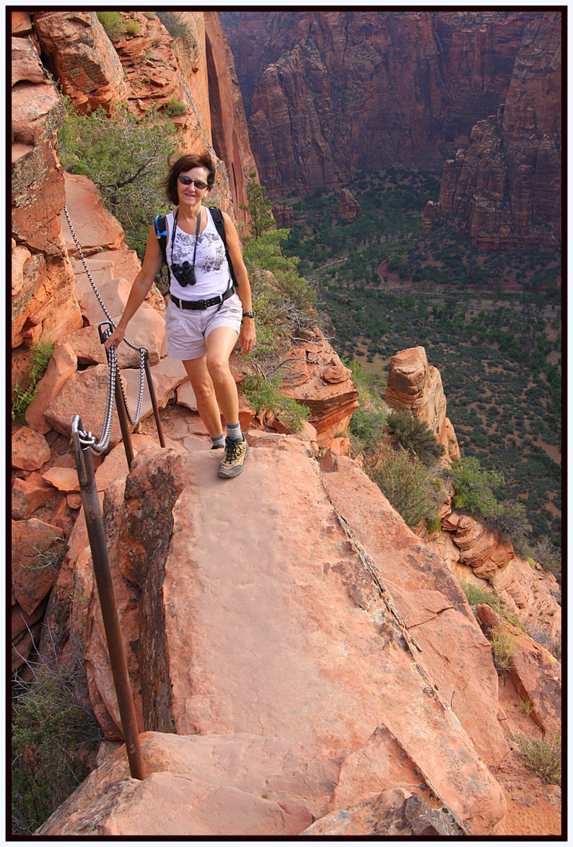
This series of photographs is meant to entice you, not frighten you. This is an absolutely thrilling route, but do not attempt the last half-mile if you fear heights. Along this narrow trail, some sections are only 24" - 36" wide. Seriously, I just checked my Journal. The vertical drops from here are 800 feet on one side, and 1200 feet on the other side.

I will try not to talk (write) too much as you enjoy the views of the Angels Landing Trail. (For you other Writers and/or Editor types: in all the resources I checked, there is no apostrophe on either side of the s)

This is only a 5-mile, round-trip hike, but it is strenuous and, as they say, rigorous!

Okay, got your water bottles or "CamelBack"? Here we go. Hang on to the chains!

Prepare to have your breath taken away!


Sarah and Mary grab some light shade in a shallow cave.


Sarah finds alternate exit.


Looking up at the ridge that we will soon be climbing.


Early portion of the chain trail, ascending the ridge.


Sarah imitates the falcon that just flew over.


That's the road, the river, and shuttle buses at the bottom.


Closer to the top, but we're not there yet.


My two favorite people in the world.


A view back at the ridgeline we just hiked.


Trace the trail along the ridge.


Looking down on the highly perched Peregrine Falcon.


Sarah gives her "Thank you God for a wonderful day" pose. She sings it aloud with her wonderful voice.


Climbing the rocks and roots with a chain assist.


I told you the trail was narrow.


That's the Virgin River well below us, circling a pinnacle named "The Organ".


Plenty of room on this platform, even for my long feet.


Havenga good time at the top. We have landed.


A shuttle bus below with 50 people aboard.


Sarah, Mary, Rich


An easy part of the trail with natural "steps".


Zion Canyon.


Lunch break on the landing. Angel feeds husband sardines and crackers.


Perched on the peak.


Mary heads back down, but waits for photographer husband. Here I come.


Mary descends "Walter's Wiggles", 21 zigs and zags.


Reward for our hot feet: a refreshing dip in the cool current of the Virgin River, back on the floor of Zion Canyon.

Here's my angel cooling her feet. I'm ready to jump in the river with her.


Trail Details:

1. Within Zion National Park, take the free shuttle service to the Grotto Picnic Area.
2. Walk across the bridge over the Virgin River to the Trailhead.
3. Follow the West Rim Trail.
4. Go through the cool, shady, "Refrigerator Canyon".
5. Climb up the zig-zagging "Walter's Wiggles".
6. Above "Scout's Lookout" is where it gets serious.
7. Be aware of anyone in your party with Acrophobia.
8. Elevation gain: 1,520 feet.
9. Trail type: Out and Back.
10. The perch at the top on "Angels Landing" holds 360* views of Zion Canyon.
11. Difficulty: Strenuous.
12. Distance: 5 miles, roundtrip. Sounds short, but it is rigorous.
13. Hiking Time: 5 hours, round trip, average.
14. Add more time for photographs.
15. Add 1/2 hour at the top to take it all in, and to revel in your accomplishments.


After 40 years of traveling the West, Zion has always been in our top three all-time favorite national parks. And they have several more trails to choose from.

Over the decades, we've hiked many trails throughout this beautiful country, but "Angels Landing" still ranks Number One.

If you are still wondering where to go this summer, we can "highly" recommend:


Landing with the Angels!